Sunday, March 17, 2013

Petetition (New Fire Island Inlet, now a.k.a. Fire Place Inlet)

Quoted from the link below–

 "The new inlet at Otis Pike Wilderness Area has demonstrated absolutely no effect on increasing tidal ranges or flooding anywhere on the bay. At the same time it appears to be clearing out the highly polluted water from the bay, giving the hope that we might avoid future algal blooms and give the bay fauna a chance to recover. Closing the inlet has been estimated to cost between $6 million and $15 million, and would likely have to be repeated in the future as a result of increasingly intense winter storms. Closing the inlet is a decision based on fear, not facts; it is expensive, harmful to the environment and will not mitigate flooding."

Hamlet Reporter
 

From: Justin Flagg [mailto:flaggjn@aol.com]
Sent: Sunday, March 17, 2013 10:19 AM
Subject: Petition


TO: 
Sen. Charles Schumer, NY
Sen. Kirsten Gillibrand, NY
Rep. Tim Bishop, NY-01
Steven Bellone, Suffolk County Executive
Rob Calarco, Suffolk County Legislator
Joseph Martens, Commissioner, NYS DEC
Wayne Horsley, Suffolk County Legislator 
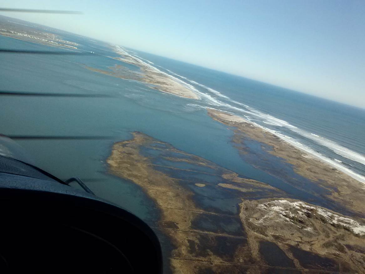
As concerned citizens we urge you not to close the inlet at the Otis Pike Wilderness Area on Fire Island, commonly known as Old Inlet. We understand your concern over increased flooding as a result of numerous storms this winter; many of us have experienced flooding and sympathize with our friends and neighbors who are afraid for their property. But there is absolutely no evidence linking the inlet to increased tidal ranges or flooding anywhere on the bay. Flooding has been occurring up and down the East Coast, from Virginia to Massachusetts – it is a regional phenomenon, not a local one.

Estimates for closing the inlet have ranged between $6 million and $15 million. These costs would likely have to be incurred again in the future as increasingly intense winter storms cause the inlet to reopen in a weakened beach. Given that there is no evidence this expenditure would reduce flooding, we suggest that such a large amount of money would be better spent protecting the communities that are most at risk. In these cash-strapped times it is incumbent on you as our elected leaders to make responsible, evidence-based financial decisions.

Finally, while the inlet is having no effect on water levels, it does seem to be having a positive effect on the water quality in the bay. Increased water exchange with the ocean appears to be clearing out the highly polluted water of the Eastern bay, providing hope that we might avoid future algal blooms and give the bay fauna a chance to recover. A healthy bay leads to healthy people, as well as thriving tourist, fishing, shell-fishing and other industries.

Again, we urge you to make this decision based on facts, not fear. The inlet is a silver lining amidst the devastation of Sandy; please do not waste millions of taxpayer dollars by closing it.

Wednesday, March 13, 2013

FW: Charles Flagg's e-mail about coastal flooding

From: Adrienne Esposito <aesposito@citizenscampaign.org>

Date: March 13, 2013 6:04:47 PM EDT

Subject: Fwd: Flooding in the western GSB


Thought u would be interested   See below


Begin forwarded message:


________________________________________
From: Charles Flagg [charles.flagg@stonybrook.edu]
Sent: Wednesday, March 13, 2013 4:18 PM
Subject: Flooding in the western GSB

Hi,
        Because of all the excitement caused by last weekend's high waters,
I have examined the water level record from Lindenhurst and compared that
with the records from Bellport and Wood Hole.  Woods Hole is included
because it is completely in another coastal region.  Attached are two
figures.  The first shows the de-tided records from the three stations and
like to plot I sent out yesterday, it is clear that these high and low water
periods have been felt all along the coast.  Sometimes Bellport gets more
water than Lindenhurst and sometimes the opposite happens.  Those are small
local effects that depend upon wind direction.  But categorically, the large
water level excursions have nothing to do with the breach at Old Inlet.  So
then I compared the tide records at Bellport and Lindenhurst before and
after the hurricane and those plots are shown in the second figure.  The
tidal amplitudes have not changed as a result of the breach.  So again the
breach does not appear to have altered conditions within the Bay.
        I completely understand the horror of watching the waters creep up
towards ones house but it does not help the situation to insist upon closing
the breach when it is clear that it is not to blame and there are clear
water quality benefits to leaving it open.
Regards, Charlie


----------------------------------------------------------------------------
----------------------------
Charles N. Flagg, PhD                   e-mail: charles.flagg@stonybrook.edu
Endeavour Hall, Rm 203          Work:  (631) 632-3184
School of Marine and                    Home: (631) 286-8925
        Atmospheric Sciences            Mobile: (631) 949-4441
Stony Brook University                  FAX:    (631) 632-8820
Stony Brook, NY 11794-5000


Steve Baloney : "We need to close the breach."


Sent: Wednesday, March 13, 2013 3:44 PM
Subject: Steve Baloney : "We need to close the breach."


http://www.newsday.com/long-island/suffolk/steve-bellone-state-feds-should-close-fire-island-breach-now-1.4807120

Steve Bellone: State, feds should close Fire Island breach now

Originally published: March 13, 2013 2:44 PM
Updated: March 13, 2013 2:55 PM
By EMILY C. DOOLEY  emily.dooley@newsday.com

Photo credit: Doug Kuntz | This photo shows the view looking north at the site of the new breach caused on Fire Island caused by superstorm Sandy. (March 9, 2013)

Suffolk County Executive Steve Bellone and other local officials on Wednesday called on state and federal officials to close a Fire Island breach created when superstorm Sandy struck last year.

"We've seen flooding in places we've never seen before...," Bellone said in a news conference at Shorefront Park in Patchogue. "We need to close the breach."

Yet Bellone acknowledged there were differing opinions about if the breach was causing flooding.

"I'm not concerned with the debate," he said. "I'm concerned about residents along the South Shore. If the breach is contributing one iota to that suffering it needs to be closed now."

Environmentalists say the flooding is a symptom of higher sea levels along the East Coast and that the breach is not causing widespread flooding in communities along the Great South Bay.

"We have been having flooding but it's not because of the breach," said Carl P. LoBue, senior marine scientist at The Nature Conservancy on Long Island. "If it was causing flooding, we wouldn't be in opposition" to closing it.

LoBue cited "some fear mongering that's causing people to make hasty decisions that won't solve the problem," and said money spent on closing the breach could be applied to shoreline hardening projects, such as raising houses.

Newsday reported Monday that the cut in the barrier island had grown dramatically since the storm hit Oct. 29.

The northern end of the breach was 276 feet wide when the opening was first measured at the beginning of November and had grown to 616 feet wide by the end of February, the latest numbers available.

The southern opening into the Atlantic Ocean measured 108 feet wide in early November and was 1,171 feet wide by the end of February. It grew by 558 feet between Feb. 20 and 28, according to data provided by the Fire Island National Seashore.

The Oct. 29 storm cut the barrier island in three places. The Army Corps closed the breaches near Smith Point County Park in Shirleyand Cupsogue Beach County Park in Westhampton. The National Seashore opted to keep open the third breach, which was located in a wilderness area near a site called Old Inlet. Officials with the National Seashore, which is overseen by the National Park Service, decided to monitor the breach to see if it closes on its own.

If officials decide to close the breach, the state Department of Environmental Conservation would have to ask the Army Corps to do the work and the National Seashore would have to issue a permit. Late last week, DEC officials said they continued to monitor the breach and had not asked for it to be closed.

Seashore spokeswoman Paula Valentine said the park would grant the permit if the state makes the request.


What to Call the new Inlet across Fire Island--Fire Place Inlet?

The following message was originally prepared by Richard Thomas, a member of the Fire Place History Club.  It has been edited to remove some extraneous material.


If we don’t get people to start using “Fireplace Inlet,” perhaps we should try for Bellport Gut.    [“Gut” -- a relatively narrow body of water.]


Actually, the new opening may be too narrow and too shallow to be a “gut,” which, if “gut” refers to something like “Plum Gut” (between the tip of the North Fork and Plum Island), must mean a fairly wide “narrow channel.”


“Inlet,” is definitely a better word, as an inlet allows a vessel to move from a larger body of water to a smaller body of water, while “gut” doesn’t imply anything about the relative sizes of the bodies of water on either side.


The problem with “New Inlet” is, of course, that new things eventually become old and the name no longer suits.


The bay was called Fireplace Bay as late as November 1878, as seen in that month’s issue of Lippincott’s Magazine of Popular Literature and Science in an article entitled “Seawanhaka, The Island of Shells”:


[If you want to know the nature of the “question so abstruse” you can access that issue of Lippincott’s Magazine at Google books.]


On the map of the Town of Brookhaven drawn by Isaac Hulse in 1797, the inlet is actually labeled "South -or New Inlet." 


Osborn Shaw implied that the map showed it as “Smith’s Inlet,” but that is not the case, at least, it isn’t the case for the image of the “Hulse map” that I have. 


"Historic Storms and Gales - Part I" by Osborn Shaw. From: Long Island Forum - Volumes 23, No. 2 - Page 31, February 1960.

   Two of the seven inlets through the Great South Beach, referred to in the aforementioned testimony of Col. Nicoll Floyd, are shown on the official map made for Brookhaven Town in 1797. One of them, known as "Hallock's Gut," was a small one and about opposite Centre Moriches; the other known as "Smith's Inlet," was west of Smith's Point and opposite Brookhaven village. It is described in the 1797 survey of the Town, as 4 furlongs and 1 chain in width, which is 4 rods more than half a mile. Both of these inlets have long since closed up. The latter began to close soon after 1800 and when the small channel was at last blocked by a brig loaded with grindstones, which sunk in its mouth about 1834, it closed up entirely and a large dune now stands over its entrance into the ocean. The other five inlets also closed up naturally and for many years there was no break through the beach east of Fire Island Inlet until on March 4, 1931, when Moriches Inlet broke through unexpectedly when there was no storm on land, but a high sea running from the effects of a storm many miles out to sea. It is just east of this inlet, that the section of the beach is known as "Cupsogue" — a term defined in Tooker's Indian Place Names on Long Island, as an "inlet that closes or shuts up." In view of the fact that old records refer to several inlets in this section, the Indian word is very appropriate, as all these inlets did eventually close up. Still further east, at Shinnecock Bay and Mecox Bay, inlets are known to have opened up and after a number of years, they too closed up entirely during the respite between Hurricanes and near-hurricane gales.


In early records, "Fire Island" was often referred to as simply the "South Beach."


cid:image001.jpg@01CE1F3C.07B9A9B0


The Bay is called the “South Bay” on the map. 


By the 1840s, the east end of the Great South Bay was known as Fire-place Bay, which I think is a much better name than “Bellport Bay,” as the bay lies mostly along the south side of Fire-place Neck. 


From the New and Complete Statistical Gazetter [sic] of the United States of America published in 1853:


The inlet is not shown in a drawing of the long and cross lots of meadow land at Fire Place that was drawn in 1753, so perhaps the inlet was, in 1797, truly a "New Inlet."


cid:image002.jpg@01CE1F3C.07B9A9B0


The inlet was definitely also called “Smith’s Inlet” before 1835.


On a map published in 1835 by David H. Burr, the inlet is labeled "Smith's Inlet." 


cid:image003.jpg@01CE1F3C.07B9A9B0


"South Shore Inlets and Places Names" by Chester G. Osborne.  From: Long Island forum - Volumes 33 - Page 117, June 1970.


Old Inlet: opposite Bellport; possibly the same as Smith's Inlet, west of Smith Point, part of the Tangier Smith property on the mainland.


The two could have been the same if one takes into account the tendency of inlets to drift westward.  Existed in the 1770's.  The pamphlet "The Story of Old Inlet" by Bigelow and Hanaway (1952) says it diminished to little more than a brook by 1836. Two ships had foundered in its mouth, which contributed to its closing. The first was loaded with grindstones and mill wheels. The second was the salt ship Syracuse which drifted into the inlet after striking a bar outside.

    The fate of Syracuse may have been the same as Savannah, first steamship to cross an ocean; Savannah ran aground off Fire Place[*]  at 3:00 a.m., Nov. 5, 1821.  An intensive search for its remains led by Frank O. Braynard about ten years ago turned up little that could be identified.  Ship's timbers are exposed after storms at the site, even now.


[*All that area east of Bellport along the south shore to the Carmans River was called "Fire Place."  In 1853 that part of "Fire Place" on the two necks of the Carmans River, Little Neck and Yaphank Neck, became "South Haven" and in 1871, the hamlet on the necks on the Great South Bay, Fireplace Neck, and the necks westward, to Bellport, Tarman's Neck, etc., became Brookhaven.]


I wonder what the name of the first ship was.  Was there a big market in grindstones in 1837?


Here is a story about the dangers of "Old Inlet," when it was still an inlet.


I found the story in:


 cid:image004.jpg@01CE1F3C.07B9A9B0


which is available on Google Books to read or download (for free).


cid:image005.jpg@01CE1F3C.07B9A9B0


cid:image006.jpg@01CE1F3C.07B9A9B0


In later years, there are pictures of hay boats that are less like a barge and more like a double-hulled catamaran. 


These can be seen on John's history web site at:


        http://brookhavensouthhaven.org/history/KostHayingP.htm


The hay boat in those pictures looks more like two small sail boats with a platform mounted across them.  It was probably nearly as difficult to steer that as it was to steer the hay barge in the story.


Richard Thomas


March 9 aerial photos of Fire Place Inlet

From: Dave Sieglinger <daveatlantic194@aim.com>

Date: March 9, 2013 6:41:00 PM EST

Subject: Old Inlet (now aka Fire Place Inlet)


All,

Attached are some pics I took from my plane today, Sat 3-9-13. You can see the Inlet with it's very strong currents and if you zoom in on some of the pic's, the Pattersquash Gun Club shack is sitting forlorn out in the bay about 400 feet from it's original island home. At least the bay does seem cleaner...

Enjoy,
Dave Sieglinger